


2023-07-09_10h56m56_lac_des_corbeaux-13570828-1688892765-493

ISATR
User
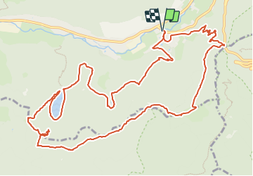

Length
15.5 km

Max alt
1149 m

Uphill gradient
667 m
Km-Effort
24 km

Min alt
725 m

Downhill gradient
667 m
Boucle
Yes
Creation date :
2023-07-09 08:56:57.69
Updated on :
2023-07-09 08:56:56.892

FREE GPS app for hiking
 SityTrail
IGN / Geographical institutes
SityTrail Plus
The world is yours!
About
Trail of 15.5 km to be discovered at Grand Est, Vosges, La Bresse. This trail is proposed by ISATR.
Positioning
Country:
France
Region :
Grand Est
Department/Province :
Vosges
Municipality :
La Bresse
Location:
Unknown
Start:(Dec)
Start:(UTM)
345604 ; 5318709 (32U) N.
Comments